Aerial
Sequence
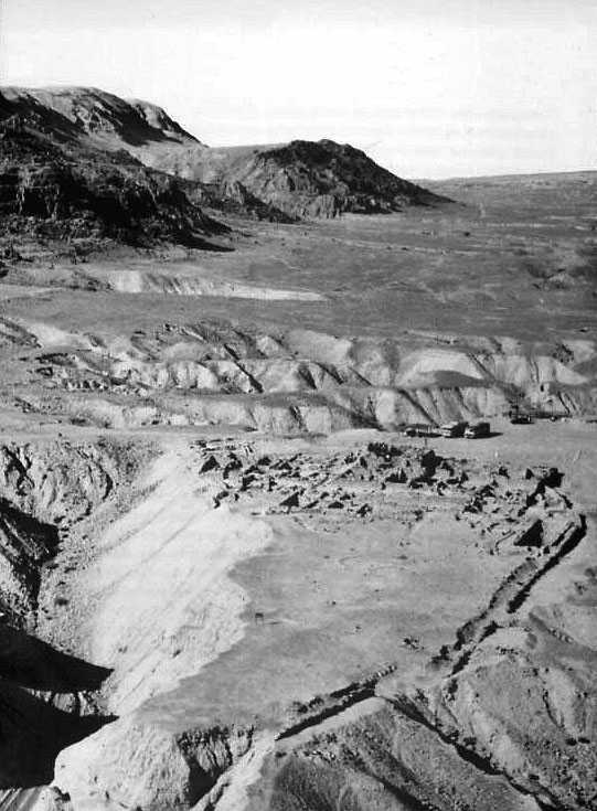
The sequence
of photos you will first see is a series of aerial shots taken from different
angles and at different points in time. This photograph must have been
taken sometime from 1951-1954, because when you compare it to some of
the photographs below, only the outlines of buildings are visible, and
there's still a lot of unexcavated earth in those buildings. The
sequence of photos begins with this exposure from the south end of the
compound looking north, and will continue as if we were flying around
the east side (right edge) of the compound. This fly-around will help
to orient you to the site.
There
are a few features worth pointing out. First, notice the cliffs to the
upper left of the photograph. The promontory is where the first Cave,
Cave 1, was found. Cave 2 is in that same cliff, while Caves 3 and 11
are even further up the coast. Second, though the Dead Sea is not visible
in this photo, it lies off the right side of the picture. Third, notice
that the compound sits on a promontory of its own. This promontory will
often be referred to as the "marl terrace," to distinguish it from the
harder limestone cliffs like those in the upper left. Finally, notice
that there's been a lot of erosion in this marl material as spring rains
have washed down from the cliffs.
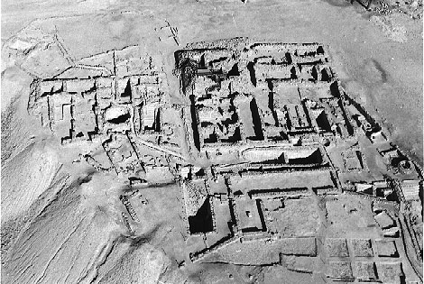
This photograph was taken at approximately the same time as the first,
and from the southern end of the compound, but now we are much closer
to the site, so that its features are more clear. You may want to have
Schiffman open to page 41; tilt the book counterclockwise about
5-degrees, and you should be able to match its features with hints of
those rooms on this photograph.
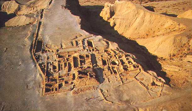
This photograph
provides a good illustration of how archaeologists work. You'll remember
from the Magness
reading that the first archaeological excavation was conducted at the
ruins ("Khirbet") of Qumran in 1951. That expedition was under the direction
of G. Lankester Harding (Director, Department of Antiquities of Jordan)
and Roland de Vaux, O.P. (École Biblique et Archéologique
Française, Jerusalem). Subsequent seasons of excavation were
carried out by de Vaux in the winters of 1953-1956. The archaeological
exploration of an area usually begins with a survey, in which small
trenchs are dug at various locations to see if any building remnants
survive. When walls are located, the trench is continued alongside them.
After the walls are established, the rooms between them are excavated.
This picture was taken after the walls had been determined, but before
the rooms had been excavated.
Notice
also the 6-square-grid in the bottom right of the photo. This is another
technique, in which square areas are excavated, leaving walkways or
"balks" between them for walking. This method also helps to expose walls.
Whichever
technique is used, an important archaeological technique is illustrated,
namely "stratigraphy." Archaeologists determine the dating of parts
of a site by what is on top of what. If a layer of ash lies on top of
a layer of pots that date to a certain period, then the archaeologist
can safely presume that a fire occurred at the end of that (pottery)
period.
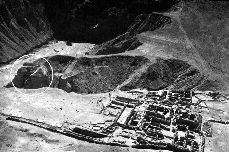
While excavations were being conducted at the compound site, the same
archaeologists were also excavating as many caves as they could in the
vicinity. The Bedouin of the region had located the richest caves, but
archaeologists had no way of knowing where the fragments they bought
from the Bedouin had come from. By excavating the caves, such as Caves
4-5 circled in white on the photo, they found pieces of some of the
same mauscripts the Bedouin had sold them, thus confirming where at
least some of those purchased fragments had come from. The archaeologists
also found pottery, leather, and metal implements in the caves, which
helped to establish some connections with the nearby compound.
This illustrates
a principle of archaeology, which is that proximity or nearness of artefacts
helps to establish their meaning. The pottery found in the caves was
like the pottery found at the compound, which suggested that the other
contents of the caves, the scrolls, were also associated with the compound.
In this more recent photograph, we are flying over the northern edge
of the Qumran compound. If you still have Schiffman's map open
on p. 41, you are approximately where the North-South circle is in the
upper right corner, looking back at the compound.
You can
get a good sense from this photograph of the eastern wall that runs
along the left edge of the compound, of the eroded cliff to its right,
and thus of how the compound sits on a promontory or cliff. A jumble
of stones to the left of the eastern wall is the main cemetery of the
complex.
This photo
is taken from the highest elevation of the site. Try to trace the path
that water would take from the bottom right elevation to the lowest
elevation of the compound in the top left.
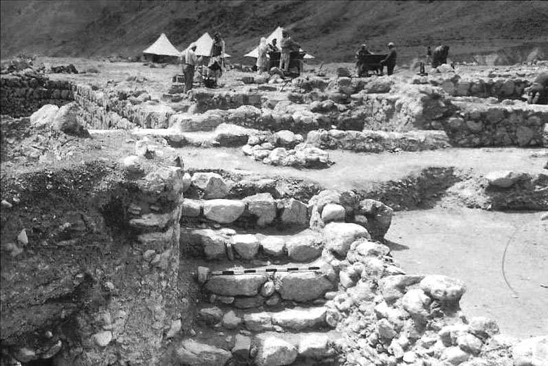
The Harding-DeVaux (1951) and DeVaux (1953-1956) excavations were carried
out in the winter because summers in the Judean desert are brutal. Here,
excavators' tents are set up in front of a staircase. Notice the meter-stick
lying on the staircase. These are used in precise line-drawings and
measurements of an archaeological site, and also help give an absolute
measurement when photographs are taken.
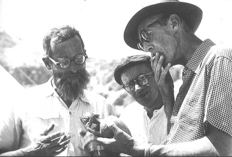
In the
photograph below, the two early, leading archaeologists are shown examining
a juglet (deVaux on the left, Harding on the right). In between them
is J. T. Milik, a Polish-born scholar who would play a huge part in
deciphering and analyzing the scrolls.
Although
DeVaux conducted excavations from 1951, 1953-1956 and published preliminary
reports of his findings, he never completed a "Final Report" analyzing
all the evidence of the site.
Archaeologists
depend on these final reports to get a sense of exactly what was found
where. In the absence of these reports, there are a lot of open questions
about the archaeology of the site, questions to which we now turn.